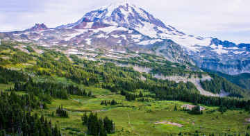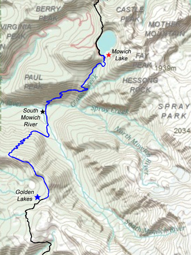
Overview
The trail from Golden Lakes to Mowich Lake is best appreciated for the subtle beauties of a virgin temperate rainforest. Unlike other parts of the Wonderland Trail, the views are modest, and the most notable sites will be Golden Lakes and later the broad valley of the Mowich River. It is a pleasant, shady walk and one can make fast time until the last three miles when one runs head-on into the steep slopes of Paul Peak and the climb to Mowich Lake. The easy downhill stretch is convenient because the South Mowich River crossing is safer earlier in the day before the sun hits the western slopes of Mount Rainier, adding more meltwater to the drainage.
If you started your trip from Sunrise, it is perhaps on this day that you will realize how much stronger a week on the trail can make you. Furthermore, you are likely to be running low on food at this point, making your step all the lighter. The climb to Mowich Lake is tough, but you have a carrot dangling in front of you: if you cached your food and the postal service came through, you likely have a bucket of deliciousness waiting for you at the top of the hill.
Golden Lakes to the Mowich Valley
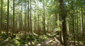
Leaving Golden Lakes the trail climbs gradually northward to the top of the ridge. The Mowich Valley comes into view, and the trail plummets fast and furiously (over 2,000 feet in elevation) in switchbacks toward the river below. The evergreens become draped with moss as one approaches the valley floor.
Mushroom Hunting
Depending on the season one may spot numerous patches of chanterelles and other mushrooms in this stretch. Mushroom hunters regularly come to the Mowich Lake area for the abundance of edibles, and this specific hillside lies just beyond the practical reach of most day-hiking mushroom pickers. A conversation with one fungi aficionado revealed that the region is a great source of edible boletes. Just make sure you know what you’re doing before eating any wild mushrooms – nothing would spoil a vacation on the Wonderland Trail like renal failure.

Give your knees a rest when you arrive at a series of little footbridges that pass over the clear-running stream near the valley floor. The forest has a magical feel about it here, and when the day is heating up, this is a great place to filter water and have a snack.
From here the trail emerges from the forest into the open flood plain. A series of temporary log bridges span the anastomosing channels of the South Mowich River.
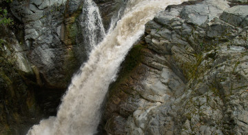
Fording the Mowich River
Early in the season you may find this to be a formidable crossing and it is possible that the log bridges have met their demise during the peak flow earlier in the year. Unless heavy rains have fallen overnight, the water level will be lower in the morning. Choose your fording location carefully. Before wading into the river, unbuckle your backpack and use your hiking poles. Go with the flow and angle your crossing towards the opposite shore slightly downstream. A lightweight pair of Vibram Five Fingers or some cheap water socks will make the crossing much easier on your feet. Fortunately, by the end of August there will likely be a bridge in place and you’ll not be remembering this crossing for its difficulty.
South Mowich River Camp
From here the valley bottom is forested in sections and you will pass by the South Mowich River Camp (2,605 feet) in a stand of forest. The north fork of the Mowich River is reached soon after. Just to the west of this crossing, the two forks of the Mowich join together and collectively drain a watershed that includes most of the northwest corner of the mountain.
North Mowich River to Mowich Lake
Traveling northward, the Wonderland Trail soon begins a long climb out of the valley, up the southern slopes of Paul Peak. In about half of a mile you will pass a junction with the Paul Peak trail which leads to the Mowich entrance station. The trail continues for over a mile across the steep hillside before running parallel to the Crater Creek drainage for the rest of the way to Mowich Lake. This can be a tough climb but it’s a good opportunity to break a sweat and see what several days on the trail can do to condition your legs.

Mowich Lake Campground
Mowich Lake Campground (4,929 feet) is a re-purposed parking lot with thirteen sites: rows of evenly-spaced, gravel-filled boxes for tent sites, each with its own picnic table, and hardly a drop of privacy (or shade). One can only hope that resident cougars do not come to make use the gravel-filled boxes at night. The campground is just past the current parking lot and tourists mill about, inviting conversation and posing for pictures in front of the lake. Considering the steady stream of traffic, this might not be the best of places to leave valuables lying unattended in the open. Though infrequent, there have been reports of theft of food caches from the storage bin near the ranger cabin.
The perks of the campground include international-class outhouses with toilet paper and hand sanitizer. In addition there is a large bear-proof box for easy food storage. If you have sent yourself a food cache, you can find it in a bin on the porch of the patrol cabin. Hopefully you have had the foresight to include several large bars of chocolate and a good screw-top bottle of wine.
The beauties of Mowich Lake more than make up for the parking lot campground. Enjoy a quiet afternoon reading on the smooth bedrock points that protrude from the shore. Mowich Lake is the largest and deepest lake in the national park, a glacial cirque, with a surface area of over 120 acres and a maximum depth of around 90 feet. The visibility in the water is extremely high, testament to the lake’s oligotrophic, or low-nutrient status (don’t count finding large fish here). This will likely decrease with time as atmospheric deposition of inorganic nitrogen and sulfur from human sources is causing both eutrophication (increase in nutrients) and acidification of this and other sub-alpine lakes in the Cascades.

The surface water is quite chilly, but brave souls will enjoy an invigorating splash. If you hike around the lake shore beyond the patrol cabin, there is a semi-secluded beach that can’t be viewed from the parking lot.
With the lack of tree cover around the tent sites, consider sleeping on a picnic table if the stars are out. On a clear night, the great depths of the sky can give one a sudden sense of vertigo. Nothing is quite like stargazing from the warmth of your sleeping bag. You won’t forget it.