Possible Itineraries
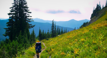
The section of Wonderland Trail between Nickel Creek and Paradise River is a busy stretch of trail. The sights are varied and the day hikers are many, especially as one nears the popular roadside attraction of Mirror Lakes.
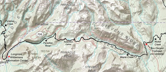
Nickel Creek to Stevens Canyon

Leaving Nickel Creek the trail passes through the forest and comes to the Box Canyon trailhead in less than a mile. If it’s early in the morning, you will beat the crowds and have the restrooms to yourself. Give yourself a few minutes to bask in the luxuries of running water and flush-toilets. After a good scrub, take the time to go visit the short trail to Box Canyon overlook where the forest floor vanishes in a sheer drop to the water, about 180 feet below. The Wonderland Trail continues from the trailhead, passing up and over the top of the tunnel through which the road runs. From here it climbs a short distance before dropping to Stevens Creek. Here a bridge crosses where the stream has smoothly ground and polished its way into the bedrock. The remarkable formations are worth a close look. Continuing on, the trail crosses two more creeks in the next mile before arriving at Maple Creek Camp (2,815 feet). A short distance ahead, the trail begins making the long and steady ascent of Stevens Canyon.
A Backpacker’s Reflections on Stevens Canyon
Stevens Canyon often gets mixed reviews from hikers. It can be difficult to climb from east to west, and I've discovered from my own trips that it's not so bad later in the hiking season.
I have have had different experiences climbing Stevens Canyon depending on the month. On a hot day in late July, the canyon can be baking in the sun, thick with humidity and mosquitoes. This makes the ascent slow and arduous, an opportunity for self-pity and daydreams of driving up the nearby Stevens Canyon Highway while drinking a cold milkshake. Fast-forward to late September and almost the entire hike up the south side of the canyon will be in the deep shade. The direct sunlight falls on the opposite wall of the canyon, igniting the autumn foliage. At this time of the year the air is clean and cool, the bugs are few, and it will likely go down in your memory as a pleasant autumn walk.

Stevens Canyon to Reflection Lakes
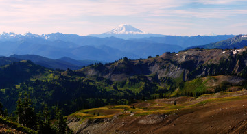
The trail leaves the valley bottom as a steady grade, making its way through stands of mixed forest and thick brush as it climbs towards the valley’s head. The summit of Rainier can be seen just above the ridge-line. Time your first rest stop for the lovely Sylvia Falls, which can be viewed from a moss-draped (and shady) stand of cedars. Another mile up the hill, Martha Falls also makes a nice stop, especially on hot days when the mist from the plunge pool cools the air and clears the mosquitoes. From here the climb steepens, and the trail crosses the Stevens Canyon Highway in about half of a mile. Keep an eye out for cars here – after days of snail’s pace through the quiet wilderness, I was quite surprised to have a Mustang to come roaring around the corner at seventy miles an hour.
Crossing the highway, the trail continues its climb to the pristine Louise Lake, marking the end of Steven’s Canyon. Rounding the south end of the lake, the day tourist density thickens as the trail approaches Reflection Lake, less than a mile ahead. For a roadside attraction, Reflection Lake is quite beautiful, but you might find yourself hurrying along to escape the crowds. If warned that if you show up here at noon on a Saturday during the height of tourist season, it can nearly be an assault to the senses: a traffic jam, idling tour buses, crowds of foreign tourists listening to guides, cigarette smoke, perfume, thumping music from passing cars, kids running around, and curious folks wanting to chat with backpackers. This is an exception, however, as most of the days there are no more than a few small groups here at any one time.

Reflection Lake to Paradise River
Pushing onward, the trail crosses the highway and after running in parallel with the road for about half of a mile, begins a descent towards Narada Falls and Paradise River. This path is wide and well-maintained and travel is easy. Narada Falls is reached within twenty or thirty minutes. It is worth the short side trip to view the 168 foot plunge of the Paradise River. From here, Paradise River Camp lies just over half a mile down the hill.
Paradise River Camp (3,805 feet) makes a good stopping point if you are traveling from Nickel Creek. Tucked into the deep forest, in many ways the camp doesn't look much different than Nickel Creek.
Paradise River to Longmire

From Paradise River Camp, the trail crosses the two channels of the creek and continues along steeply at times as it follows the drainage towards Madcap Falls and Carter Falls. Here a well-built railing runs along the edge of the overlook. Further down the hill, remains of an old water pipe from a hydroelectric operation can be seen at times along the side of the trail.
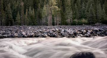
It is a fast walk to the Nisqually River crossing which is just below Cougar Rock Campground on the west bank. Stepping out into the river bed, Mount Rainier comes into view, a strikingly different perspective than when it was last seen at Reflection Lakes. This face is more pyramid-shaped, and it looks like a completely different mountain than the famous silhouette on the Rainier Beer can. After crossing the braided channels of the river, Longmire is just a short walk ahead through the forest.