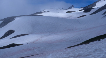
Early season warning
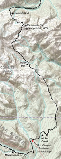
Panhandle Gap is the highest point on the Wonderland Trail at 6,750 feet. It is often covered by snowfields until late summer. Consequently, it can be a challenging and dangerous route, particularly early in the hiking season (before August) when melting snow erases the outline of the trail, making route-finding difficult. Rapid snow-melt forms transient streams and snow bridges, and footing can be treacherous. A fall on one of the steeper snowfields could carry a hiker far from the trail.
Please take care when hiking in this area. Always check with the park service about trail conditions before hiking over Panhandle Gap. Even on a clear day, it can be easy to lose your way between Panhandle Gap and Indian Bar if the trail is buried under snow.
In 2014 a solo hiker vanished in this area. It was early in the season and he presumably became lost and met a tragic end. His remains were found in 2015 near Fryingpan Glacier, up the mountain from this area. This tragedy underscores the importance of caution and preparedness.
Carry navigational aids, know how to use them, hike with a partner, and hike in-season.
Summerland
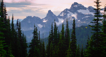
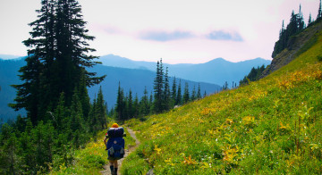
Summerland is a gateway to the highest section of the Wonderland Trail where it crosses Panhandle Gap at 6,750 feet. This is also one of the most visually impressive sections of the trail, offering expansive views of both Mount Rainier and much of southern Washington. On clear days, Mount Hood can even be seen poking above the hills in northern Oregon. It is common to hike from Summerland to Nickel Creek in one day (11.3 miles), but if you’re going to drag your heels anywhere, this is the place to do it. You could do this stretch in two days and stay at Indian Bar (about 4.5 miles from Summerland) if you want to have time to soak up the sights.
Summerland to Panhandle Gap
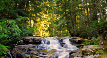
As the trail leaves Summerland it rises like a staircase through the highland meadow, pausing briefly by a mossy stream bordered by a bouquet of wildflowers. Above, a web of cascading waterfalls is highlighted by the green carpet of mosses it feeds. Summerland is the headwaters of Fryingpan Creek, and all of the streams in the area leave via this drainage. As you climb away, the meadows thin to nearly lifeless expanses of glacial moraine. Early in the summer, this area will likely be buried under snow, and if the trail is not visible, keep an eye out for the flags marking the route. The trail crosses a busy stream via a footlog and continues across the moraine, passing by green, milky tarns as the views become more grandiose with each step. The path then turns to a series of steep switchbacks as it approaches Panhandle Gap, and climbs right past a pyramid-shaped crest to the east. From here, the next mile of Wonderland Trail has undoubtedly made Fuji and Kodak a lot of money back in the days of film cameras.

When clouds roll over, a sense of desolation consumes the alpine landscape; passing through here in the fog is a surreal experience.
It is quite a different story on a clear morning: the delectable views remind you that you are in the middle of every element of landscape that one might hope to find in the Cascades. In summer, the snowfields stretching down the mountain turn into vibrant green hills that become densely covered in forest as they roll away to the south. The snow-capped ridge-lines of Goat Rocks Wilderness beckons nearby, and beyond, the pristine profiles of Mount Adams and Mount Hood mark the backbone of the Cascade Range. Turning around, the views of Rainier could neither be more rugged nor more complete: like a great castle of rock and ice the volcano fills up the sky; the parapet of Little Tahoma peers over Whitman Crest, piercing the blueness of space.

Panhandle Gap to
Indian Bar
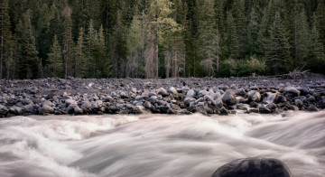
Descending the other side of the divide, the trail rolls through high alpine meadows above Ohanapecosh Park. This is often covered in patches of snow until autumn. Boulders jut from the smooth terrain where they lie fallen from avalanches high up the mountain. Early in the season, finding the route can be a slight challenge here as the through-traffic may be insufficient to keep a well-defined trail in the rapidly melting snow. If you lose your way, head to Indian Bar at N46o 49.59′, W121o 38.27′, but take care to avoid descending the mountain prematurely into Ohanapecosh Park where a number of streams and a ridge must be crossed in order to reach your destination. The route continues across the high plateau and gains about 300 feet in elevation to reach a viewpoint of the glacial cirque of the upper Indian Bar valley. After a short climb, the glacial cirque valley of Indian Bar comes into view and far below you should be able to make out the outline of the emergency shelter against the valley bottom. The path then begins a fast drop down the ridge which separates Indian Bar from Ohanapecosh Park.

At 5,120 feet, Indian Bar is a pleasant campground and courageous individuals can even shack up with the mice on one of the shelter’s wooden bunk beds. In 2009, the structure got a partial remodel including a new roof and a few other repairs. A half-century’s worth of pocket-knife graffiti covers the inside and could provide enough reading material for an entire evening. Two streams converge right below the camp before tumbling off a short falls (over which a bridge has been tastefully built). Following this downstream just a short hike from the campground, you will find the much larger Wauhaukaupauken Falls.
Indian Bar to Nickel Creek
Heading south, the next stop is Nickel Creek, about six miles from Indian Bar. The trail piggybacks a ridgeline, and Indian Bar will likely be the last source of water until you get to Nickel Creek – drink up. Climbing steeply out of Indian Bar, the path follows the ridge through the sparsely-forested meadow. The views steadily improve as the mountain steps into full view behind Cowlitz Park. This ridgeline is like a series of dull saw teeth and the walk is strenuous as it covers each rise. Sometimes the path seems to lead straight into the sky next to Mount Adams in the distance. Looking back, the sights of Rainier rising above the sub-alpine meadows are magical. In the valleys on either side of the ridge, bears can often be spotted in the summer as they gorge on berries. If one is preoccupied with the views, the miles can slide past quickly. Before long the trail drops from its heights, losing 800 feet in elevation to the junction with the Cowlitz Divide trail. Here, the Wonderland Trail turns sharply westward, and begins a rapid two mile descent to Nickel Creek, losing another 1,500 feet elevation over the remaining distance.

Nickel Creek Campground
The camp at Nickel Creek (3,385 feet) is located in the deep forest and is a peaceful place to stay. Ten years ago, the sites were located right near the creek, but now they have been moved up the hillside a short distance due to blow-downs. This was once a wild zoo of rodents and the mice partied hard all night as they combed through the backpacks and scampered around the outside of the tents looking for crumbs. The last time I stayed here, however, I didn’t see a single mouse or chipmunk. It was a huge improvement and I heavily suspect the park service had something to do with it. Please keep track of (and hang) your scented goods here to avoid another mouse population boom.